
(First Draft - posted on: April 10, 2013 by David McMillin)
Geography is “a science that deals with the description, distribution, and interaction of the diverse physical, biological, and cultural features of the earth's surface” (Merriam-Webster, 2002). Thus, as part of a project intended to graphically tell the story of Atlantis, envisioning the geography of Atlantis is essential.
If Atlantis existed, where was it? How big was it? What were its boundaries (shape and outline)? What did it look like with regard to terrain? Was it flat, mountainous, wet or dry? Did it have rivers, lakes, and bays that significantly affected the cultural development of its inhabitants? Did its location relative to other lands effect cultural exchanges and the development of the human species? These are the sorts of questions that readily come to mind when contemplating Atlantis as a physical reality (and not simply a convenient construct for advancing a particular philosophical or political position). In this section we will survey the geography of Atlantis with the aid of the Cayce readings and the writings of Plato.
The location and extent of Atlantis was told to Plato’s ancestor Solon by an Egyptian priest:
For these [Egyptian] histories tell of a mighty power which unprovoked made an expedition against the whole of Europe and Asia, and to which your city put an end. This power came forth out of the Atlantic Ocean, for in those days the Atlantic was navigable; and there was an island situated in front of the straits which are by you called the Pillars of Heracles; the island was larger than Libya and Asia put together, and was the way to other islands, and from these you might pass to the whole of the opposite continent which surrounded the true ocean; for this sea which is within the Straits of Heracles is only a harbour, having a narrow entrance, but that other is a real sea, and the surrounding land may be most truly called a boundless continent. (Plato, Timaeus, Cooper & Hutchinson, 1997)
The key points of this story are:
1. Atlantis was located in the Atlantic Ocean in front of the Pillars of Heracles (Straits of Gibraltor).
2. Atlantis was a very large “island” (larger than Libya and Asia combined).
3. From Atlantis one could pass to other islands and thus to an opposite “boundless” continent.
4. By comparison, the body of water within the Straits of Heracles (Mediterranean Sea) is quite small (only a harbour) compared to the Atlantic Ocean which is a “real sea.”
It is amazing that Plato could have displayed such knowledge of geography so as to correctly describe the relative size and positions of these major landmarks. This is one of the primary reasons that some writers have chosen to take Plato’s account of Atlantis as literal, rather than simply a fiction created to convey a philosophical or political viewpoint.
Plato’s account of Atlantis is not limited to a general statement of geography, but is rather explicit about the location of mountains, a great plain and major city. The city was constructed in a pattern of three concentric canals connected to the ocean by a rather long ditch. The surrounding regions also made use of such waterways to transport materials to the city from the mountains and agricultural regions outside the city.
Whereas the writings of Plato clearly place Atlantis in the Atlantic Ocean outside the Mediterranean and beyond the Straits of Gibraltar, this hasn’t limited theories about the location of the famous sunken land. In fact, writers with various agendas have proclaimed the discovery of Atlantis in almost every region of the globe from Troy (Zangger, 1992) to Indonesia (Santos, 2011) and even Antarctica (Wilson & Flem-Arth, 2000).
The Cayce readings on Atlantis actually reference the writings of Plato (ECR: 364-1) and provide a geographical overview of the landmass that is fairly consistent with the writings of that noted philosopher:
1. Atlantis was located in the Atlantic Ocean (ECR: 364-3). This may seem obvious, but is crucial given the abundance of theories that have placed Atlantis almost everywhere else in the world.
2. Atlantis was large. The Cayce readings make the comparison of the original size of Atlantis as Europe and Asia (in Europe) combined (ECR: 364-6). Cayce appeared to be following Plato’s lead in this regard. To establish the extent of Atlantis, comparison with known landmasses of the time were drawn. Presumably Cayce could have given the dimensions in square miles or such, but preferred a comparison to other known landmasses, as had Plato. Furthermore, in the Cayce readings, the size of Atlantis was relative to the timeframe. Before the geophysical events that destroyed Atlantis, it was quite large and became progressively smaller with each period of destruction or upheaval.
3. With regard to the geography and layout of the major city described by Plato (“the ancient metropolis”), the Cayce readings again show some remarkable parallels with the Greek philosopher. According to the readings, early Atlantean cities utilized a circular design with considerable use of waterways (ducts, canals, pools) for commerce, recreation, and utility (ECR: 2121-2, 364-12).
4. Like Plato, a major city (Poseida) described by Cayce was built on a hill (364-12). Plato described it as a “mountain not very high on any side.” Plato noted the presence of mountains in the distance from the city. Several Cayce readings do mention the mountains of Atlantis in various contexts (e.g., ECR: 4353-4, 1740-1, 364-4).
With this overview in mind, let’s focus on some geographical details.
As noted, the Cayce readings place Atlantis in the northern portion of the Atlantic Ocean. At this point, we are speaking of the full Atlantean landmass before being reduced to islands.
The position as the continent Atlantis occupied, is that as between the Gulf of Mexico on the one hand - and the Mediterranean upon the other. Evidences of this lost civilization are to be found in the Pyrenees and Morocco on the one hand, British Honduras, Yucatan and America upon the other. There are some protruding portions within this that must have at one time or another been a portion of this great continent. The British West Indies or the Bahamas, and a portion of same that may be seen in the present - if the geological survey would be made in some of these - especially, or notably, in Bimini and in the Gulf Stream through this vicinity, these may be even yet determined. (364-3)
In contrast to Plato’s description of a final, catastrophic destruction of Atlantis, the Cayce readings portray the changes in the landmass of Atlantis as a series of disturbances and geologic upheavals culminating in a final destruction as given by Plato. Thus the initial (pre-destruction) size of Atlantis was more continental (or at least a sizable island continent). Following each period of destruction, the size of the landmass was reduced until it consisted of three main islands at the time of the final destruction which would have corresponded to about the time described by Plato (approximately 9,600 B.C.E.).
At the time of Amilius (circa 106,000 B.C.E. per Little et al, 2006, p. 50) before any periods of destruction discussed in the Cayce readings, Atlantis would have been quite large:
(Q) How large was Atlantis during the time of Amilius?
(A) Comparison, that of Europe including Asia in Europe - not Asia, but Asia in Europe - see? (ECR: 364-6)
It would seem that the readings are following the lead of Plato in defining the extent of Atlantis by comparison with contemporary landmasses. In Plato’s case, Atlantis was said to be larger than Libya and Asia combined. In Plato’s worldview, this might equate to North Africa along the Mediterranean Sea plus Asia Minor. Likewise the Cayce readings draw a geographical comparison of Europe and the western portion of Asia associated with Europe.
Using Webster’s Geographical Dictionary as a guide, Hutton and Eagle (2004, p. 249) defined “Europe including Asia in Europe” to include the far northern islands of Norway (Svalbard) and Russia (Novaya Zemlya and Kolguyev) with the eastern boundary Europe following the Ural Mountains, Ural River, and Caspian Sea. The area of such a landmass could reasonably be regarded as a continent stretching from the Bahamas, across the north Atlantic nearly to Europe and Africa on the eastern edge.
Another way of thinking about the size of Atlantis as described by Plato is to consider it as an expanse of islands. “Plato’s Atlantis dialogues related not to a single landmass the size of Libya and Asia together, but to the extent of the proposed island empire.” (Collins, 2000, p. 244) Actually, from the Cayce perspective, this way of conceptualizing the extent of Atlantis would probably be more relevant to the latter period of Atlantis when it would have consisted entirely of islands that had survived the earlier geophysical disasters.
Two Cayce readings do provide a crude outline for the shape of continental Atlantis. Both are included as graphic elements in aura chart readings:
Upon the left side put the outline, in a circle, of Atlantis. This would be near an outline of the continent now of Australia. (ECR: 303-31)
Upon the left, in the lower side, put the map, in a circle, of Atlantis; not Poseidia but Atlantis as a whole, - and thus much in the form or shape of Asia, if it were separated in the present, though indentations in the lefthand portion indicating a gulf or a bay. (ECR: 2301-3)
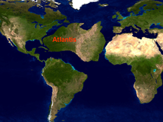
Plato’s description of the geography of Atlantis and the mountainous terrain on three sides surrounding the capital city sounds a bit like the mid-Atlantic ridge in the area south of the Azores. Using the shape of Australia and the approximate size cited above by Hutton and Eagle, I have made a crude illustration of the continent of Atlantis prior to any periods of geophysical upheaval. In this image, I have placed the mid-Atlantic ridge as a mountain range running down the continent as it might have been during that era (assuming the description of size and location provided in the readings). Admittedly, this is purely speculative and intended to convey a general impression, much as it would have done in an aura chart sketch.
Interestingly, an aura chart reading given for Edgar Cayce himself includes a mountain as a graphic feature associated with Atlantis:
Above this indicate a mountain, and the symbol or sign that is the symbol of Gemini - or the two-bodied figure, or united bodies as a figure (small), on the edge of this mountain. The vegetation here would be very verdant, in the central portion; this shading off to the left in that as of the temple, - or the crystal, or an obelisk with the crystal in the top. This, to be sure, would not be too large a figure; with many figures at worship about the light that comes from this obelisk.
On the right side would be the fields with laborers in chains or bonds. This, to be sure, would indicate the period in Atlantis when there was the separation of the sexes indicated among things, or the thought-figures or bodies; those that had caught the vision and those still kept in bondage. (ECR: 294-206)
A reading given for a forty-eight year old woman in 1930 includes the evocative image of watching the destruction of Atlantis from the vantage of mountain tops:
In the one before this we find in that period when Atlantean forces were in activity. The entity then among those that gathered in the mountain tops and watched over the destruction by the incoming of waters, and over the vast expanses as were made by the receding of waters. (ECR: 1740-1)
Keep in mind that Plato’s description of Atlantis was a plain surrounded on three sides by mountains. Given a mountainous setting for Atlantis (or at least significant portions of it), one can speculate on the possible location of Atlantis based on this premise. Thus, the Mid-Atlantic Ridge and its associated mountains have been cited as possible locations for Atlantis. (Hutton & Eagle, 2004)
Considering that Bimini has received a lot of attention by researchers following leads in the Cayce readings, the presence of mountainous terrain is a little problematic. Essentially, the Bahamas of which Bimini is part, consist of low-lying islands. There are no significant mountains nearby. The highest point in all the Bahamas just 206 feet on Cat Island. The nearest real mountains are on the volcanic islands of the Caribbean.
A curious reading given as part of a series on commercial development of Bimini does allude to mountain tops at Bimini:
There will be found many, many, MANY sources of revenue for those undertaking such a project, for these mountain tops - especially that along the north and eastern shores of the north and northern portion of the south island - will produce many various minerals, and various other conditions that will be remunerative when the projects are undertaken; and well that the ones that do such labors - as the dredging as necessary, the building as necessary, the walls, etc. - be followed close in their operations, for these will uncover many various conditions that may be turned into dollars - and dollars - and dollars! (ECR: 996-12)
Hutton and Eagle interpret the mountain tops mentioned in this excerpt as being relative to the general conformation of the Bahama Platform which is cut by intervening deep water channels.
If all the waters of the Banks were to disappear, the Banks themselves would appear as mountains. In this sense then, one might suppose that islands like the Bimini Islands, the Cat Cays, Andros, and other smaller islands could be considered the very tops of mountains of carbonate sediment known as the Great Bahama Bank. (Hutton and Eagle, 2004, pp. 302-303)
During the last ice age ocean levels were hundreds of feet lower than in the present, so that even without significant sinking the Bahamas might appear to contain low mountains. Furthermore Hutton and Eagle hypothesize that a coming pole shift (rotational axis of about 1 degree) could alter the topography of the region around Bimini producing “a visual impression of a mostly flat-topped type of mountain rising out of the ocean. Observers of the scene would be looking at a steep-sided mass of mostly grayish-white limestone standing roughly 1000 ft above the surrounding waters” (Hutton & Eagle, 2004, pp. 303-304). We will be considering the possible role of pole shift as a factor in the destruction of Atlantis in another section.
From a broader perspective, mountainous terrain associated with the southwestern extremes of Atlantis could be found in the Carribean to the south of the Bahamas. Continuing with reading 996-12, while keeping in mind that Bimini consists of two islands (North and South), consider the implications for lands to the west and south of Bimini:
…for this is of the first highest civilization [Atlantis] that will be uncovered in some of the adjacent lands to the west and south of the [Bimini] isles, see? (ECR: 996-12)
Andrew Collins (2000) has done a very thorough job of exploring the Cuban hypothesis as the location for Atlantis, which may be relevant to any consideration of the mountains of Atlantis.
With the fracturing of continental Atlantis during repeated periods of geophysical destruction, the land was fractured, broken up, and reduced to islands, eventually only three in number:
(Q) Was Atlantis one large continent, or a group of large islands?
(A) Would it not be well to read just that given? Why confuse in the questionings? As has been given, what would be considered one large continent, until the first eruptions brought those changes … Then with the breaking up, producing more of the nature of large islands, with the intervening canals or ravines, gulfs, bays or streams … (364-6)
(Q) What were the principal islands called at the time of the final destruction?
(A) Poseidia and Aryan, and Og. (364-6)
Several Atlantean cities are mentioned in the Cayce readings. When considering the excerpts below, keep in mind that the land of Poseida may have been a distinct region of the continent of Atlantis that remained above the waters after the various periods of destruction.
In the one before this we find in that land known as Poseida. In the city of Amaki did the entity rule as the priestess to the fire worship and to the precious stones that were gathered together during that sojourn. (413-1)
Before this, we find in the land of Poseida [Atlantis], when Alta was in the height of its civilization. (234-1)
In the one before this we find in that land known as Poseida, and in the cities of that land. (240-2)
In a reading given in 1933 for a thirty-five year old woman, the city of Eden on the island of Poseidia was mentioned. Note the context: The building of the temple dedicated to the Law Of One took place before the second of the turmoils that broke up the land into islands. Also note that Eden was located in Poseidia:
Before this we find the entity was in the Atlantean period before the second of the turmoils that separated the islands or broke up the land into islands; and in the city of Eden in Poseidia did the entity then dwell.
The entity was among the Atlan lands and peoples, and in the same sex, and of those that served in the temple during the building of the temple to the One, the law of the One, the understanding of the law of the One. (ECR: 390-2)
Naturally one can wonder about possible Biblical connections for such a city given the readings tendency to draw parallels in such matters (i.e., Adam, the flood of Noah’s time, etc). Did this city somehow relate to the Garden of Eden story in the book of Genesis? Reading 364-4 refers to Atlantis as the “Eden of the world.” Reading 364-7 speaks of the “the Atlantean or Eden experience.” Perhaps this is merely a linguistic co-incidence or a strictly symbolic connection since other readings (ECR: 364-13;1179-2) provide a middle eastern placement of the garden of Eden consistent with mainstream thinking on the subject. Church (1989, p. 110) sought to integrate the Atlantean city of Eden into a broader soul story of the Biblical Adam and his fall from grace.
The first few readings that discuss Atlantis use the term Alta as synonymous with Atlantis. The readings also mention an important leader named Alta, for whom the city was named.
In the one before this we find in that fair country of Alta, or Poseidia. (ECR: 288-1; November 20, 1923)
(Q) Is this the continent known as Alta or Poseidia? [Atlantis]
(A) A temple of the Poseidians was in a portion of this land.
(ECR: 996-12; March 2, 1927)
This was being waged between the followers of the patriarchs of old; of Alta, of Quoauda, and those that directed against the sons of Baalilal. The entity was among those that were active as to the exchange of associations with those in the Poseidian land, or in the city of Alta. (378-13)
The readings mention both Poseida and Poseidia, at times seemingly interchangeably. Keep in mind that the transcriber of the readings usually had to spell Cayce’s trance talk based on phonetics. Gladys Davis, Edgar Cayce’s personal secretary who transcribed most of the Atlantis readings, acknowledged that she had to guess at the spelling of Atlantean words based on Greek mythology (ECR: 288-1). Sometimes the entranced Cayce would spell words, which appears to have been the case in the following excerpt:
In the one before this we find in that land known as the Atlantean, and in that city known then as the Poseida, or P-o-s-o-d-o-i-a itself. (ECR: 2122-1)
This practical aspect of transcription could account for some of the variability in the spelling of Poseida and Poseidia. Thus it is reasonable to assume that the variance in spelling is an artifact of the process.
The following brief mention of Poseidia in a reading given for an aura chart describes both the island and city of Poseidia. Note the shape of the island and the relative position of the city of Poseidia in this excerpt:
Upon the left side put the island of Poseidia; this almost rectangular in its shape, with the base being the longer edge, and in the center - in the base - would be the projection, or two curves there, upon which there would be indicated the city, or a town, of Poseidia - which would be written on (and this in a circle), in the color of coral pink. (379-18)
Poseida was described as a large, important (in terms of commerce and prosperity) city:
(Q) Describe briefly one of the large cities of Atlantis at the height of its commercial and material prosperity, giving name and location.
(A) This we find in that as called Poseida, or the city that was built upon the hill that overlooked the waters of Parfa, and in the vicinity also the egress and entrance to the waters from which, through which, many of the people passed in their association with, or connection with, those of the outside walls or countries. This we find not an altogether walled city, but a portion of same built so that the waters of these rivers became as the pools about which both sacrifice and sport, and those necessities for the cleansing of body, home and all, were obtained, and these - as we find - were brought by large ducts or canals into these portions for the preservation, and yet kept constantly in motion so that it purified itself in its course; for, as we find, as is seen, water in motion over stone or those various forces in the natural forces purifies itself in twenty feet of space.
In the type of the buildings, these were much in that of tiers - one upon the another, save principally in the temples … (ECR: 364-12)
As discussed above, presumably the city of Poseidon was synonymous with Poseida and Poseidia. Reading excerpt 1741-1 suggests that his area of land had a long Atlantean history stretching back to the “old Atlantean.” Also note that Poseidia was the land in which the Law of One faction had its greater activity.
Before that we find the entity was in that now and then called the Atlantean land, in the city of Poseidon, when there had begun the fires of the rebellions that brought about those activities by those of high authority in portions of the activities of the land that made for its destruction.
The entity then was among those of the household of Aja (?), in the name Amelelia, and acted as the priestess to those in the Temple of Light, that made for the guiding of those things pertaining to the motivative influences in the MATERIAL affairs of individuals … (ECR: 812-1)
In the one before this we find in the land known as the Poseidan, or a portion of the old Atlantean. (ECR: 1741-1)
In the one then before this we find in that land known as the Atlantean, and in the city or country of Poseidia. (ECR: 2135-1)
Before that the entity was in the Atlantean land, during those periods when the second destruction had brought so many of the islands, and when the Poseidian land was the greater in power … (ECR: 2157-1)
Before that the entity was in the Atlantean land, at those periods when there were the second divisions, or when there was the destruction of the lands which made Poseidia the remaining portion in which there was the greater activity of the sons of the Law of One. (ECR: 2562-1)
Church, W.H. (1989). Edgar Cayce’s Story of the Soul. Virginia Beach, VA: A.R.E. Press.
Collins, A. (2000). Gateway to Atlantis: The Search For The Source Of A Lost Civilization. New York: Carroll & Graf Publishers, Inc.
Cooper, J. M. & Hutchinson, D. S. (Eds). (1997). Plato: Complete Works. Cambridge: Hacket Publishing Company.
Hutton, W., & Eagle, J. (2004). Earth’s Catastrophic Past and Future: A Scientific Analysis of Information Channeled by Edgar Cayce. Boca Raton: FL. Universal Publishers.
Little, G., Little, L., & Van Auken, J. (2006). Edgar Cayce’s Atlantis. Virginia Beach, VA: A.R.E. Press.
Merriam-Webster. (2002). Webster’s Universal Encyclopedic Dictionary. New York: Barnes & Noble Books.
Santos, A. (2011). Atlantis – The Lost Continent Finally Found. Berkeley, CA: North Atlantic Books.
Wilson, C. & Flem-Ath, R. (2000). The Atlantis Blueprint: Unlocking the Ancient Mysteries of a Long-lost Civilization. New York: Delta.
Zangger, E. (1992). The Flood from Heaven: Deciphering the Atlantis Legend. New York: William Morrow and Company.